- BEFORE YOU ARRIVE IN THE FAROE ISLANDS
- Accessibility for disabled
- Advice for LGBT travelers
- Alcohol
- Customs
- Electricity
- Electric cars
- Health & safety
- Money
- Passport and Visa
- Phones & internet services
- Postal service
- Public holidays
- Tax-free shopping
- Time Zone
- Useful numbers & service
- What to pack
- Winter in the Faroe Islands
- GUEST ARTICLES
- Discovering the Faroe Islands by bicycle
- Uncovering a different side to the Faroe Islands
- Tórshavn marathon
- The Faroe Islands... through the eyes of a New Yorker
- Fog with a chance of hihing in the Faroe Islands
- G! festival: cue the music for nature lovers
- Sheep farming in the Faroe Islands
- Suðuroy: A hikers's haven
- The food culture of the Faroe Islands


You haven’t got any favourites yet
This is where you can collect inspiration, articles, events and places that interest you.
Click the icon on pages and they’ll appear here.
Your favourites
Inspiration & Articles
Events & Tours
Places
Hiking
INSPIRATION & ARTICLES
EVENTS, TOURS & HIKES
PLACES


You haven’t got any favourites yet
This is where you can collect inspiration, articles, events and places that interest you.
Click the icon on pages and they’ll appear here.
Your favourites
Events & Tours
Places
Hiking
Haraldssund - Skarð


Link Copied!

-
 Kunoy
Kunoy -
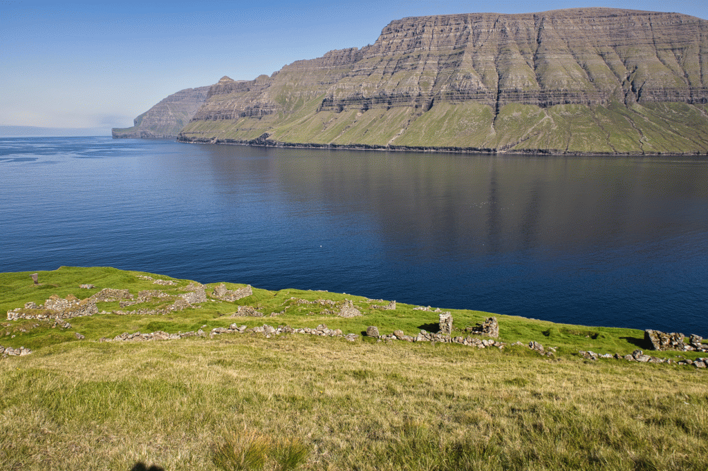
 The village Skarð also had a boat house by the river Búðadalsá, 2.5 km. south of the village, where conditions were better in bad weather. On the other side of the strait, we glimpse the green infield at the village of Skálatoftir, which was abandoned in 1914, while Skarð was abandoned in 1919. Photo: Óli Gardshodn.
 -
 View along the river Mataráin, down over the abandoned village Skarð. On the other side of the fjord, a little to the right of the picture, we see the gorge Ásugjógv, which they used for an emergency port when they did not have the opportunity to row home. Inside the gorge, they could pull the boat up onto a sandy beach. Photo: Óli Gardshodn.
 -
 The path from the village Skarð down to the landing site. Photo: Óli Gardshodn.
 -
 Kleivin, the landing site at the village of Skarð. Not particularly practical and without protection against the sea waves. Photo: Óli Gardshodn.
 -
 Memorial in the village of Skarð in memory of the men who died in 1913 with the boat Skarðsbáturin. Photo: Óli Gardshodn.
This awestriking route which along the coast to the ruined village of Skarð.
The route starts by the boat basin north of the village Haraldssund. The path becomes more visible once you are a little further along the beach. Many brooks and streams are along the way heading north, and please be cautious where the bedrock is slippery.
In the past, there was much communication between Haraldssund and Skarð, and the path between these two villages connected them for centuries.
It is uncertain how old the village of Haraldssund is; however, it is believed that both Haraldssund, Kunoy and Skarð are exceedingly old villages. Haraldssund is a calm place, and in the olden days, all the villages in Kunoy had boathouses in Fiskimøl, which is just south of where the tunnel entrance is today.
The route to Skarð is fascinating because it runs close to the beach, and you can hear the waves hit the cliffs and see the cliffs and mountains stand above you. Kunoy is the highest island in the Faroe Islands and has no less than six of the ten mountains that stand above 800-meters in the Faroe Islands. Many areas are not walkable, and we advise you not to wander into the mountains of Kunoy without an experienced guide.
Once you have walked about 1.5km, you arrive at Skarðsmannastíggj, where the men in Skarð would travel up after fishing with the men from Haraldssund men. First, they would head up Skarði and row with the Haraldssund men south to the rockface, and then from there, they would walk back north to Skarð.
The men in Skarð had a boathouse in Búðadal, and these ruins can be seen just north of Búðadal lake, which was the old indicator between the two villages. On days when the sea was too rough in Skarð, the men used the boathouse in Búðadal or rowed to Haraldssund.
After about 5km, you can see Skarð and the house ruins, which seem extremely small down by the beach. Whilst we walk towards Skarðdal, at 500-meters, the high rock edges under Kúvingarfjall and Middagsfjall start to appear. Once we reach Skarð, we can see right up on the mighty Skarði with the largest gorge in the Faroe Islands, the gravelly Skarðsgjógv.
Follow the path north of the village past the unique waterfall in Skarðdalsá; on the other side of the pool is Skálatoftir, which is also a ruined village. Then walk past the stone fence at the top until you suddenly arrive at the house ruins.
From the village, there is a decent path heading down to Kleivina, where you can see how difficult it would have been for Skarð people to float boats in the area.
On the 23rd of December in 1913, seven Skarð men and a boat were sunk and lost at sea due to sudden bad weather. The village lost all of their best working men in one day. Life became hard, and the village was deserted in 1919. There is a memorial set up in Skarð to remember the men lost at sea.
We recommend giving yourself time to enjoy the stillness and view in Skarð before you continueing back home.
If you decide to hike from Skarð to Kunoy through the gorge reaching an elevation of 618 metres, we only recommend doing this with an experienced guide. The route is challenging and potentially dangerous if you take the wrong path. This route is only suited for very experienced and fit hikers.


Haraldssund - Skarð
Route 504 heads to Haraldssund:
https://www.ssl.fo/fo/ferdaaetlan/bygdaleidir/500-504-klaksvik-kunoy/
Parking in Haraldssund:
Decent parking on the north side of the quarry in Haraldssund; park your car down there, facing the sea. To avoid blocking access to exits and work equipment lying on the quarry's upper side—refer to the green line. Then walk north along the road through the stone fence at 75-meters—note the blue line.


Haraldssund - Skarð - Kunoy
Facts

Duration

distance

Peak

Elevation
 Not suitable for children.
 Difficult
- For the most part, it is decent and grassy terrain. Certain areas are wet, and it can be challenging neart the brooks.
Difficult
- For the most part, it is decent and grassy terrain. Certain areas are wet, and it can be challenging neart the brooks.

Region / Trail Difficulty

 Difficult
 5 km /
2h
5 km /
2h


 7 km /
2h
30m
7 km /
2h
30m
